South Coast NSW History Story
(Surveyor) Thomas Townsend
Thomas Townsend (1812 – 1869)
Colonial-era surveyors are the South Coast’s (indeed, Australia’s) unsung heroes.
These men were sent to previously unexplored areas, tasked with mapping what was there – natural features such as rivers and mountain peaks, and were required to report on the area’s suitability for grazing or agriculture, and whether there were any indications of the existence of precious metals. They then selected sites for towns or villages, in many cases also actually laying out the towns, and selected the sites of other areas that should be reserved for government use. And the boundaries of properties already occupied by squatters, or likely to be sold in the near future, were surveyed and mapped. These surveys then effectively determined where the district’s roads and river crossings would be sited. In many respects, these ‘surveyors’ were as much explorers and they were surveyors…and their decisions largely determined how and where different areas then developed.
Surprisingly, these surveyors received little recognition and their names are pretty much all that history has recorded. (For example, we currently know nothing about Assistant Surveyor Drake who was responsible for laying out the current town of Bega - not even his first name, let alone what other surveys he may have been responsible for.)
Surveyors along the South Coast included (in alphabetical order) Assistant Surveyor Drake, George William Evans, Thomas Florance, Robert Hoddle, Edmund Kennedy, James Larmer, Thomas Mann, James Meehan, John Oxley, Samuel Parkinson…and Thomas Townsend.
Townsend was responsible for surveying vast swathes of present-day Victoria and southern NSW. Today, he is largely unknown. His sole legacy is Australia’s second highest mountain, Mt Townsend, that bears his name. Despite his numerous achievements, he does not even rate a mention in the Australian Dictionary of Biography.
Thomas Townsend was born and trained in England. In July 1829 he arrived in Sydney, most likely as a crew member aboard the convict ship Waterloo. After experiencing some difficulty obtaining a position, he was finally hired as a draftsman by the Surveyor General’s Department in April 1831.
In August 1838 he was promoted to the position of Assistant Surveyor, and so began what was to become a life in which he traversed (sometimes riding, often on foot) and mapped an enormous area of the country – first in the Southern Highlands of NSW, then along the Murray River (he laid out and surveyed Albury), then as Acting Surveyor-in-Charge of the Port Phillip District in Victoria, then in the Western District of Victoria (where he laid out and surveyed Portland and Port Fairy), then in Gippsland, then in the Monaro, then (from July 1842 to November 1843 whilst Surveyor-in-Charge of the ‘Monaro Squatting District’) on the South Coast of NSW where he undertook surveys from the Moruya River to the Victorian border (he laid out and surveyed both Eden and Pambula townships), then in the Snowy Mountains area, and finally in the ‘Murrumbidgee Squatting District’.
His output (completed maps and reports on what he had discovered, which was what the Surveyor General’s Department was seeking) was prodigious. As a result (as his biographer Peter Crowley explains), the Surveyor General of New South Wales, Thomas Mitchell, praised him (an unusual thing), Deputy Surveyor General Samuel Perry was in awe of him, and Governor Gipps regarded him as the best officer in the survey department. In official circles, it was a generally held view that the colony could not do without his services.
Over his career, he gradually rose in seniority within the Surveyor General’s Department – but this was principally because he constantly reminded the powers-that-be that he deserved to be promoted and that he should not be overlooked when promotions were being considered. In September 1851, Townsend was informed of his appointment to the position of Second Surveyor on an annual salary of £375. He was now the fourth most senior surveyor in New South Wales, after the Surveyor General, Deputy Surveyor General and First Surveyor.
In December 1853 Townsend was appointed NSW’s Acting Deputy Surveyor General (the Surveyor General, Thomas Mitchell, was on extended leave in England and the Deputy Surveyor General, Samuel Perry, was on sick leave that was to culminate in his retirement). Tragically, just as he was reaching a pinnacle in his career, Townsend suffered a complete mental breakdown the following month, rendering him totally unfit for any further duty.
He returned to England in July 1854, leaving his wife (who he had only married in April 1853) and a young son (who he would not accept as being his own) in Australia. He suicided in London in August 1869. He was buried in an unmarked grave – so, like so many of his considerable lifetime achievements, unrecognised and with no public memorial.
Among the many ‘distinctions’ that Townsend had during his life was that he was once held up by bushrangers. This is Peter Crowley’s telling of the story:
On 29 March 1850, Townsend travelled from Kyeamba to Tarcutta on ‘the mail’: a stage coach used to transport mail and passengers. The bushranger Robert Edward Knox and an accomplice stopped the coach and asked the mailman for a passage, which was refused. The accomplice pointed a pistol at the mailman, telling him to stop or he would have ‘scattered his brains’, then Knox drove the coach into a secluded area a quarter of a mile off the main road, sitting between Townsend and the mailman. The men’s attention focussed on Townsend. He was ordered off first, tied up with strips of hide and searched. The surveyor’s boots were removed, followed by his trousers, then Knox pulled his underwear down and tied it around his ankles. Townsend was left to be bitten by march flies while the men searched ‘the swell’s’ saddle bags. The bag contained a bill of exchange for £341, which was addressed T.S. Townsend, Esq. One of the men mockingly remarked that ‘we did not know that we were robbing an esquire’. After reading the bill, they returned it to Townsend but took some letters belonging to him, including money orders, a compass and a map of the Murrumbidgee. The hide strips were removed, after which Townsend was allowed to put on his trousers. He was then bound to the wheel of the mail cart with his own silk handkerchief. The bandits departed. The mailman gnawed through the handkerchief, releasing Townsend’s hands, and allowing Townsend to untie him. The entire episode lasted 45 minutes.
Robert Knox was apprehended on 9 April at Honeysuckle Creek on the Goulburn River in New South Wales, 300 miles from the location of the robbery…Knox was convicted by a jury and sentenced by his Honour Justice Therry to hard labour for ten years, the first three of his sentence to be served in irons.
Thomas Townsend was engaged in surveying the Australian Alps region in October 1842. His aim was to traverse and map the entire Main Range – broadly the area from Tabletop Mountain (east of Khancoban), across Kosciuszko and down through the Pilot Wilderness into the Cobberas in present-day Victoria. However, he was advised by Thomas Mitchell, the Surveyor General, that he should conduct a survey at Twofold Bay because ‘application having been made by a gentleman (the influential, well-funded Benjamin Boyd) for some portion of land’ and that he should also reserve some land for a government town in the area.
Townsend’s plans to personally survey and map the Snowy Mountains’ Main Range, before then heading to the coast, were thwarted by ten successive days of snow (in October!), so he had to leave surveying of the Monaro to other teams of surveyors that he supervised whilst on the South Coast.
Townsend felt that a very important feature which requires to be traced, viz. the sea coast from Moruya River to Cape Howe _(now the eastern end of the NSW - Victorian border), _which from observations made in my late survey I am enabled to state in all the charts hitherto published (are) very inaccurately defined. So, he undertook a survey extending from the Moruya River to the Genoa River, which he was unable to cross because of the unavailability of a boat.
In February 1843, Townsend sent details to Sydney of 15 farms and 100 allotments that had surveyed, along with a plan for the town of Eden. He also surveyed and mapped the Bega River, from its source to its mouth, and laid out the township of Pambula.
(Townsend himself subsequently purchased land in Eden township, as did Boyd – who did so with the intention of never developing it, thereby hoping to prevent Eden becoming a competitor to his own town, Boydtown! However, Benjamin Boyd was declared bankrupt in 1848, ending his dreams that Boydtown would become the most important port between Sydney and Melbourne.)
Source: Townsend of the Ranges by Peter Crowley, National Library of Australia Publishing, 2024.
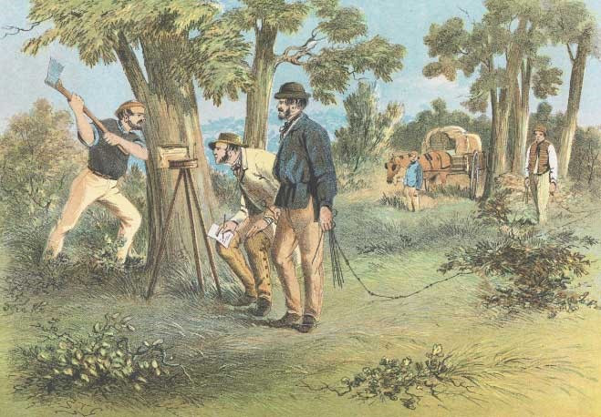
Illustration: S.T. Gill’s somewhat romanticised 1864 painting, ‘Surveyors’