South Coast NSW History Story
CURRARONG
‘Currarong’ is believed to be derived from a local Aboriginal word meaning ‘place of many winds’.
n the late 1830s Alexander Kinghorne and his sons tried grazing and farming on his estate called Mount Jervis, which basically covered the area north from Currarong to Kinghorn Point. In the 1840s one of the family established a land-based whaling business near Montagu Point on Jervis Bay. It is not known for how long this operated.
The first land grant in what is now the town of Currarong was of 34 acres in 1858. It was made to Helen Jane Mackay, daughter of the first Crown Lands commissioner in Nowra.
The first person thought to have settled in Currarong was Alex Carvis in the 1890s. Initially a collector of gum from grass trees, he built a hut and took campers fishing in small boats and from the cliffs.
From the 1880s, the southern part of Beecroft Peninsula was used by the Royal Australian Navy for bombing and for offshore to onshore target practice. It is now known as the Beecroft Weapons Range. In 1955 shells from the Black Prince, a New Zealand ship doing exercises with the RAN, landed in the Currarong village!
Slowly, Currarong became a popular fishing and camping spot. In the 1920s and 1930s more fishermen and families moved to Currarong,
Helen Mackay’s land was purchased in 1928 by Henry F Halloran, the real estate developer who acquired and developed extensive areas of coastal land on the South Coast. He subdivided it in 1930.
Currarong’s history has been inextricably linked to that of the nearby sea. Fishing – both recreational and commercial – has long been a principal activity. Abrahams Bosom (offshore, north of the town) has provided shelter to ships. And, the SS Merimbula ran aground on Beecroft Head, north-east of the town, in 1928, ending passenger services to the South Coast that had previously been provided by the Illawarra and South Coast Steam Navigation Company.
In 1899 the Point Perpendicular Lighthouse, at the southern end of Beecroft Peninsula, was built to replace the ineffective (because it had been built in the wrong location) Cape St George Lighthouse on the southern peninsula to Jervis Bay.
In 1998, Currarong became part of Jervis Bay Marine Park.
Bushfires in the surrounding area (particularly on the Beecroft Peninsula) have been recent regular recent occurrences, with fires recorded, for example, in 1965 (when 13 houses and buildings were burnt), 2015, 2016 , 2019-2020, 2023 and 2025.
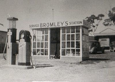
Image: Bromley’s Service Station, Currarong 1944