South Coast NSW History Story
CULBURRA BEACH
Culburra was originally called Wheeler’s Point after George Wheeler, one of the first landholders in the area. He owned 158 acres at Kinghorn Head (now Penguin Head) and some land around Lake Wollumboola.
In its early years the Culburra region was used for timber getting and sheep grazing, with a wool wash located near the boat ramp at Lake Wollumboola. And Curley’s Bay was named after an Aboriginal shepherd who worked for Alexander Berry (see Coolangatta Estate).
In 1891, 233 acres of land adjacent to the Crookhaven headland were notified as a recreation reserve. Soon after, the Aboriginal Protection Board decided to relocate Shoalhaven Aboriginal people from Berry’s Coolangatta Estate. So, 27-acres were taken from Crookhaven Park at Orient Point and became the Roseby Park Aboriginal Reserve in 1900. With over 100 people in the reserve, including 42 children, in 1903 the area’s first school opened – the Roseby Park Aboriginal School. In 1907 the Aboriginal Reserve was expanded by a further 39 acres by the Aboriginal Protection Board.
The emerging coastal town at Wheeler’s Point had its name changed to Culburra, from an Tharawal Aboriginal word meaning ‘sand’, by real estate developer Henry Halloran around 1916. Halloran had purchased most of the land in the area in 1915 and had subdivided it by the next year.
Halloran had plans for a major settlement called St. Vincent City with a distinctive circular layout influenced by the designs of Walter Burley Griffin. Orient Point (from 1917) and Culburra (from 1922) were to be the first suburbs. It was envisaged that a railway would connect St Vincent City with Jervis Bay.
However, development was slow, even though the district was becoming known as an enticing holiday area in the 1920s. So, in the early 1920s, Halloran built Culburra House, a 13 bedroom guesthouse, and a 9-hole golf course to attract visitors to the area. (During World War II, Culburra Guesthouse became uneconomical to run. It was sold in 1952 and was transported to Nowra for use as part of the Riverhaven Motel. In moving the house, the road to Nowra was damaged and Council sought £186.4.8 compensation (we’d be interested to learn whether they actually received any compensation!).)
The lack of basic facilities hindered the early development of the town. Fresh water had to be pumped from a well above Culburra Beach, electricity was not connected to the area until the 1950s and, until 1956, the road to Culburra was unsealed.
Around 1960, only 70 dwellings had been erected. This grew to around 120 by 1969. Most were low-cost holiday cottages. In 1976 the school opened and in 1978 there were 240 houses in the town.
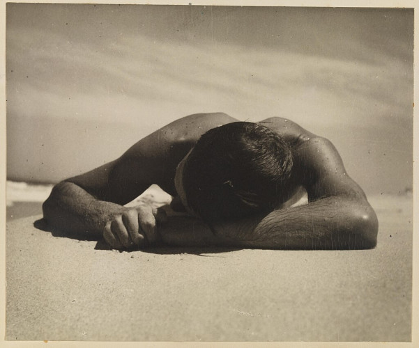
Culburra Beach was the location of the quintessentially Australian photograph ‘Sunbaker’ by Max Dupain. The man in the photograph was Harold Salvage, a British builder, who was part of a group of friends visiting Culburra Beach on a surfing trip in 1937.
‘It was a simple affair. We were camping down the south coast and one of my friends leapt out of the surf and slammed down onto the beach to have a sunbake – marvellous. We made the image and it's been around, I suppose as a sort of icon of the Australian way of life.’ — Max Dupain
Image: The original ‘Sunbaker’. It was slightly altered (his clenched hand was opened up) in the more-familiar 1970s print.
