South Coast NSW History Story
ARALUEN
When gold was discovered in the Araluen Valley to the north-west of Moruya in 1851, the landscape changed almost instantaneously.
The word ‘Araluen’ is believed to be a local Walbanga Aboriginal word meaning ‘place of waterlilies’, describing an originally-abundant feature of the billabongs and the waterways of the area. These rapidly disappeared!
The first Europeans explored the area in 1822, and within a few years the valley had been accurately mapped.
By 1835 Henry Clay Burnell had purchased 1,280 acres in the valley for £265 and became the first settler in the area. His farm house and farm buildings were erected with the help of convicts.
The following year Andrew Badgery began grazing cattle in the area. He was later to make his fortune supplying goods to thousands of miners who flocked to the area and by charging them to prospect on his properties.
In 1848 a road was constructed using convict labour from the Valley to Moruya.
In September 1851 two Moruya men, Alexander Waddell and Harry Hicken, discovered alluvial gold in the Araluen Valley after they had noticed that local terrain resembled that in the rich gold-bearing area around Ophir near Bathurst.
Almost overnight, thousands of prospectors had moved to the area. Most usually arrived by ship at Broulee and then walked overland to the goldfields.
Many were to be richly rewarded. One history suggests that in Majors Creek in the early days prospectors were recovering an average of one ounce of gold per man per day.
Within a year, an estimated 100,000 ozs (2,830 kg) of gold had been recovered. And this was just the start!
The Araluen goldfields (which actually extend up on to the tablelands towards Braidwood and are still being worked today – for example at the Dargues Reef Mine near Majors Creek) gained a reputation of being one of the richest goldfields in Australia and the workings extended for many miles along the creeks in the area. Major gold deposits were exploited at Jembaicumbene, Majors Creek and Araluen – with Araluen itself being divided into six districts: Upper Araluen, Bourketown, Newton, Crown Flats, Redbank and Medmelong.
As it turned out, the richness of the Araluen goldfields was to be anything but the proverbial flash in the pan – with the Araulen goldfields ending up having a longer life and being capable of supporting more miners than most other Australian alluvial goldfields.
So, significant infrastructure was built, such as a road that was constructed between 1856 and 1861 up the mountain from Araluen to Majors Creek and Braidwood.
Water races were also installed from as early as 1855 – some to feed water so that gold could be extracted from the gold-bearing sands, some to drain water way from ever-deepening shafts: ‘The great drawback to testing (penetrating) the ground has been the underground leakage. The depth is nothing, in no case exceeding forty feet, but when the fine grey sand has been reached, then comes the water which nothing but powerful pumps and engine-power can subdue. So it stands to reason that the ordinary miner, with his windlass and bucket, has been quite unable to bottom a shaft in this locality. (So) during this last year or so, companies have been formed with a goodly amount of capital to bring up (build) tail races of stout timber and covered over. These…are now beginning to develop the almost inexhaustible bed of auriferous (gold-bearing) dirt composing the bottom layer on the granite.’('Freeman’s Journal', 14th February 1880). (A long article, describing an ambitious plan to build a race along the whole length of the Araluen Valley goldfields to drain the area is included in the 'Sydney Mail and NSW Advertiser' of 7th March 1896, accessible on Trove.)
(Water, in fact, proved to be a major and on-going challenge to the area. Either there was far too much (as described above and below) or there was too little, with significant droughts between 1875 and the 1890s posing considerable challenges to the miners and the mining companies in the area.)
At its peak in the 1860s and 1870s, 30,000 men were working the area. There were around 26 hotels, 20 butchers and numerous general stores, bakers, shoemakers, blacksmiths, churches and banks catering to the needs of residents.
It is believed around 700 Chinese were attracted to the Araluen goldfields at this time. The miners often worked in organized groups of 30 to 100 men, which resulted in their gold-digging efforts being very successful…much to the resentment of local European miners.
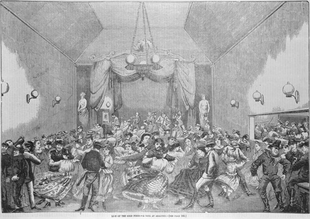
(Goldmining by the Chinese was very much a man’s game. In 1880 there were fewer than 100 Chinese women in NSW, compared to a population of 10,000 Chinese men. Not that the gender imbalance was restricted to the Chinese miners: Local ‘hotels nearly all had amusement halls attached to them, and grand dances were frequently advertised, the different houses vying with each other as to which could bring off the best ball – the ‘best’ usually meaning the wildest, for fun in those days was mostly of the furious kind. So that the miners should be afforded some relief from the monotony of dancing with each other, the thoughtful promoters of the dances occasionally went to the trouble and expense of bringing parties of girls up from Sydney and other towns as partners for them. Such enterprises were widely advertised, and, as a rule, no doubt, brought cash as well as kudos to the promoters.’)
It seems race relations on the Araluen goldfields were unusually good – perhaps particularly thanks to the efforts of a Chinese man, Quong Tart.
It is estimated that by 1896 an incredible £11,000,000 worth of gold had been taken from the Araluen Valley goldfields.
On January 1st 1860 the Araluen Valley was hit by a devastating flood. ‘Moruya - The First 150 Years’ reported ‘The loss of life was heavy. In one case a hotel and all its occupants were swept away, and the bodies of several of those in the building at the time were found afterwards on the beach at Moruya. Much later that year the workings were reopened but they never returned to their former glory or excitement.’
The wealth of the area inevitably attracted bushrangers. On 13th March 1865 Ben Hall, Johnny Gilbert and Tom Clarke unsuccessfully attempted to hold up a gold coach headed to Braidwood near the top of the mountain on the Araluen to Majors Creek Road, but were outflanked and forced to flee. One policeman was wounded in the encounter. The coach involved has been restored and is on display at the Braidwood Museum.
In 1869 reef mining (where gold is extracted from seams running through quartz rock, which is crushed by large stamping batteries) commenced in Majors Creek and by 1871 five battery crushers were operating in the area. These were extracting over 100 oz of gold per week.
And from 1870 mechanisation in the form of hydraulic sluicing (the use of high-pressure water cannons) was introduced to the area. This made recovery of the gold very much easier because overburden above the gold-bearing strata was often up to 12 metres in depth.
In 1899 yet another major change to extracting gold in the area occurred when the first dredge started operation. This must have been a profitable undertaking because eventually 11 other dredges were working nearby. (As an indication of the profitability of dredges operating in the valley, the Araluen No. 1 Dredge, constructed in 1900, paid twenty dividends totalling £8,000 and another dredge, the Central No. 2, was able to be constructed at a cost of £4,400 from the profits it generated.)
However, by the late 1930s dredging had stopped and the valley basically returned to become a grazing and farming area – despite specific efforts being made during the 1930s Depression to revive mining to provide employment in the area.
From the early 1900s a Cheese factory operated in the Valley. It was taking milk from 11 suppliers, ‘all of them being well-to-do dairy farmers and graziers of the district’ and produced around 6,000 lb of cheese per month. And from the 1930s orchards and market gardens were established, with peach production ultimately becoming one of the main incoming-producing activities in the area – offering gold of a different form to local residents.
Sources: Wikipedia and Trove; Sydney Morning Herald 8th February 2004; www.majorscreek.org.au; ‘Majors Creek Gold Deposits’, NSW Resources & Geoscience; Sydney Living Museum; ‘Araluen, 1901 – a Town in Transition’ and ‘Moruya – the First 150 Years’, Moruya & District Historical Society; ‘Araluen, N.S.W’, www.aussietowns.com.au.
Illustration: 'Life on the Goldfields: A Ball at Araluen', 1867. nla.obj-138069581-1
Further information provided by Myles Hannan (myles.hannan@iinet.net.au) from his ‘Descendants of Patrick Madigan’ study:
Araluen is located 16 miles (26 kilometres) south of Braidwood.
In Greville's Directory, Michael Maddigan was listed as an innkeeper at Burke Town, Upper Araluen. It is known that he was the proprietor of the Currency Lass at Middle Araluen. From his children's birth certificates he lived at Burke Town, Araluen from 1867 to 1872 and at Majors Creek from 1874 to 1881.
Majors Creek was a mining settlement 8 miles (13 kilometres) north west of Araluen.
The first gold rush in the Braidwood area was in 1851. According to McGowan, a second boom began in 1857 and this lasted until 1874. Floods were a major issue at Araluen, the gold being mined in the various creeks that flowed into the Araluen Valley. In February 1860 a flood caused death and destruction on a major scale.
Another flood in April 1867 caused extensive damage to the equipment then in use in the Araluen goldfields. It was estimated that about 2,000 miners were put out of work by this flood. Yet another disastrous flood occurred in 1871.
McGowan comments that in the early years of the second boom period (1857- 1874) there were 40 public houses at Araluen and a number of them held dancing five nights a week, engaging professional dancing girls for this purpose. McGowan further remarks that by the early 1860s there was a marked change for the better in the nature of the valley's social life.
A period of lawlessness was experienced in the mid 1860s in the Braidwood district associated with the activities of Hall, Gilbert and and the Clarke brothers, who lived south west of Braidwood. In March 1865 Ben Hall and his gang attempted to hold up the gold escort as it was climbing the steep and narrow track between Araluen and Majors Creek (the climb from Araluen to Majors Creek is more than 1500 feet, or 450 metres). One of the gang was identified as Tom Clarke, one of the Clarke brothers. Note that this was only a month after the shootout at Mutbilly.
McGowan states that by 1870 there were three distinct townships, Redbank, Newtown and Burke Town (all located close to Araluen Creek). Burke Town was west of Araluen Creek, Newtown to the north east and Redbank to the south east (based on McGowan's map). Thwaites also identifies Mudmelong, Crown Flat and Deep Creek as suburbs or areas of Araluen. Deep Creek is well north of the main part of Araluen, situated between the headwaters of Araluen Creek and Bells Creek; Crown Flat was a mining settlement, south of Redbank on the east side of Araluen Creek; Mudmelong was a mining settlement, south of Crown Flat on Araluen Creek. From the Royal Australian Survey Corps map of Araluen (1974), it is about six miles (10 kilometres) from North Araluen to Lower Araluen, though, following the path of Araluen Creek, it would be considerably further. There is conflicting evidence about the location of Lower Araluen relative to Crown Flat.
From McGowan's map and the Royal Australian Survey Corps map, Crown Flat lies between Upper Araluen and Lower Araluen. From Greville's Directory, Lower Araluen lies between Upper Araluen and Crown Flat, based on coach arrival and departure times.
Conflicting figures are given about the population of the Araluen goldfields - Richard Kennedy claims up to 30,000 but figures from the 1856, 1861 and 1871 censuses suggest a peak population of no more than 12 000.
The 1871 Census identifies only 4 239 residents of Araluen, 1 339 at west Araluen (Upper Araluen, including Burke Town and possibly Newtown) and 2 900 at east Araluen (including Redbank, Mudmelong, Merricumbene, Favourite Flat and Crown Flat).
As with the Lachlan River, there is confusion in the naming of the Deua River (pronounced "Dewey"). Some maps (eg McGowan) show the upper reaches of the river labelled the Deua River and the lower reaches, after the junction with Araluen Creek, as the Moruya River. The Geographical Names Board of NSW identifies Moruya River as being a former name for the Deua River and recognises only the tidal estuary as being labelled the Moruya River. The Board describes the Deua River as a "perennial stream rising about 5 km south east of Bendethera Mountain. It flows generally south, west, north, north east, south, south east and east,making almost a complete circuit, for about 80 km to become the Moruya River at about Kiora, the Moruya River being the tidal estuary of this stream". The overall shape of the river is like an interrogation mark rotated 90º anti-clockwise. The junction with Araluen Creek is at its most northerly location. It is reported that in the early 1850s the way to get to Araluen was by ship from Sydney to Moruya, then walking along the banks of the Moruya and Deua Rivers and Araluen Creek, crossing from one side to the other more than 30 times.
Greville's Directory lists Upper Araluen, Lower Araluen and Crown Flat as Post Towns and identifies Burke Town as an address in Upper Araluen and German Flat, Back Creek, Mudmelong, Bettowynd and Merricumbene as addresses associated with Crown Flat. German Flat was a mining settlement, but is not identified in modern maps. Back Creek was a farming settlement up on the tableland, west of Majors Creek settlement and is also included in the Majors Creek Post Town; Back Creek flows north to the Shoalhaven River. Bettowynd was a farming settlement south west of Mudmelong; Bettowynd Creek flows south east into the Deua River, upstream from the junction with Araluen Creek. Merricumbene was a farming settlement on the Deua River, downstream from the junction with Araluen Creek.
In Burke Town in 1872 were the following occupations: blacksmith, bootmaker, butcher, carter, farrier, gold commissioner, hairdresser, innkeeper, miner, minister (Rev Thomas Llewellyn), storekeeper and teacher.
Other occupations in Lower Araluen (additional to those in Burke Town) included: auctioneer, baker, bricklayer, carpenter, carrier, chemist, dealer, engineer, farmer, fruiterer, gardener, grocer, groom, manager Bank NSW, manager Oriental Bank, newsagent, photographer, postmaster, saddler, storekeeper's assistant, tailor, tanner, teamster, tinsmith, veterinary surgeon, waterman, wheelwright and woodman.
Other occupations in Upper Araluen (additional to those already listed) included: cooper, market gardener, sawyer and settler. Other occupations in Crown Flat included: dairy (at Mudmelong and Crown Flat) and stock-keeper (at Bettowynd).
Interestingly, based on Greville's Directory, there was no doctor (MD) listed in Araluen in 1872 – Rees Llewellyn and Peter Gentle were the MDs in Braidwood in 1872 and their names appear on several death certificates for Greenwoods and Madigans. In contrast, the 1871 Census provides conflicting information, there being two doctors at Araluen. McGowan identifies the two doctors resident in Araluen as Rees Llewellyn and Peter Gentle. The 1871 Census also indicates that there were 4,239 residents in Araluen, compared with only 1,197 in Braidwood.
Based on Greville's Directory, there were many more occupations in Braidwood (despite the smaller population), together with occupations which also existed in the Araluen Valley:
accountant AJS bank, accountant Oriental Bank, agent, AJS Bank, assistant storekeeper, auctioneer, bailiff, baker, Baptist minister, blacksmith, bootmaker, bricklayer, builder, butcher, Church of England minister, carpenter, carrier, chemist, clerk, coachbuilder, compositor, contractor, cordial manufacturer, CPS (Clerk of Petty Sessions?), dealer, dentist, farmer, fruiterer, gaol warder, gaoler, gardener, gold commissioner, grazier, groom, hairdresser, hawker, horse breaker, hospital warder, householder, innkeeper, ironmonger, Justice of the Peace (JP), labourer, landowner, mail contractor, manager Oriental Bank, MD, miller, miner, Oriental Bank, overseer, painter, plasterer, porter, poundkeeper, Presbyterian minister, proprietor of Dispatch, saddler, sawmill, sheep inspector, shepherd, solicitor, stationer, storekeeper, Superintendent Police, surveyor, tailor, tanner, teacher, Telegraph office clerk, Telegraph station master, tinsmith, upholsterer, watchmaker, waterman, Wesleyan minister, wheelwright and whitesmith.
Araluen boasted Anglican, Catholic and Presbyterian churches, a Wesleyan chapel and a Baptist chapel, three post offices (Upper Araluen, Lower Araluen and Crown Flat), a newspaper office, two police stations, "many" hotels, three banks, three public schools and five private schools. Among the hotels was the Currency Lass at Burke Town, run by Michael Madigan from 1867 to 1872, before he turned to goldmining at Majors Creek where he died in 1882. Majors Creek was a mining settlement north west of Araluen, on the tablelands above the Araluen Valley - the settlement of Majors Creek is about 2 000 feet (600 metres) above sea-level, whereas the floor of the Araluen Valley is less than 500 feet (150 metres) above sea-level.
According to McGowan, the floods in 1871 spelt the end of the Araluen goldfields apart from a brief period in the 1880s and the dredging boom of the 1900s. In May 1872 the Town and Country Journal reported that, since the 1871 floods, "the amount of poverty and destitution experienced by many a hard working family is beyond all that my tongue or pen can express". Given the move of the Madigans from Araluen to Majors Creek between 1872 and 1874, it would appear that the Madigans got caught up in the disastrous effects of the 1871 flood. McGowan comments that in 1872 the number of public houses had also decreased.
The poet Henry Kendall (1841-1882) made Araluen his home for a while and his eldest child, who died as an infant in 1871, was called Araluen. He wrote two poems called Araluen, one about the Araluen Valley, the other about his recently deceased daughter.
Upper Araluen was 205 miles (328 kilometres) south of Sydney. In 1872 mail was delivered six days a week, either by rail to Goulburn and coach to Upper Araluen via Braidwood, or by steamship to Nelligen and coach to Upper Araluen. Based on Greville's Directory, mail arrived at Upper Araluen at 3:5pm, Lower Araluen at 3:30 pm and Crown Flat at 3:45pm, indicating that Crown Flat was located south of Lower Araluen.